Lost Property
The battle over Sticky Forest.
By George Driver
On a hilltop in Wānaka surrounded by one of the wealthiest neighbourhoods in the country sits 50 hectares of douglas fir and radiata pine. The block was given to the descendents of 50 Māori left landless by a duplicitous Crown purchase. One hundred-and-seventy years later, the heirs to this block are finally set to take ownership. For the Wānaka community, it’s a new grievance in the making.
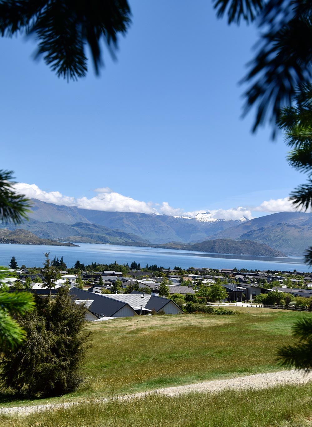
Looking out from Platinum Ridge, Lake Wānaka is sparkling below like an infinity swimming pool. Cloud shrouds the still snow-flecked peaks of the Southern Alps across the lake to the north-west, and you can just see the zig-zags of the popular Roys Peak Track nearby, winding up through tussock and rock to its summit at 1578m. Just to the east, unseen, the Clutha River begins its 338 kilometre path to the sea.
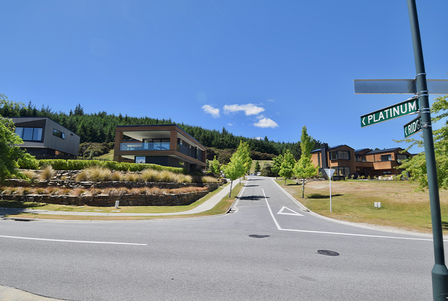
It’s the kind of backdrop people refer to as a million-dollar view, but on Platinum Ridge it costs significantly more than that. The only remaining section — a flat 900m² site with houses on three sides — has an asking price of $1,485,000. A neighbouring 297m² home sold for $2.917 million in April — still potentially a bargain at $600,000 below rateable value.
Around the corner, maple saplings line the street of Forest Heights, where it feels like walking through the pages of an architecture magazine — an exhibition of cedar, industrial concrete, triple glazing and cantilevered steel that enable 300m² homes to appear to float.
Just behind these two streets is a 50.7 forestry block of radiata pine and douglas fir, creating a jagged silhouette. While the adjacent real estate listings suggest the block could be worth hundreds of millions of dollars, this hilltop block is producing cheap timber, planted with tree species officially considered a pest. It has a rateable value of just $7 million.
While it’s bordered by one of the country’s wealthiest neighbourhoods, this land has been allocated to the descendants of 50 Māori who were left landless by the Crown. Almost 120 years after land on Lake Wānaka was allocated to them as compensation, its rightful owners are still waiting to take possession. But the wait is almost over. An impending land transfer will end a grievance spanning generations. For the Wānaka community, it comes at the expense of one of their most treasured parks, in a move some view as privatisation by stealth.
It all started with a letter from Governor George Grey.
The Sale
It was a simple plan. Somehow it all went wrong. On 8 April, 1848, Governor Grey ordered his underling, Lieutenant-Governor Edward Eyre, to buy roughly half of the South Island on behalf of the Crown, in what remains the biggest buy up of Māori land in history. Grey, however, seemed eager to avoid any ongoing grievances arising from the deal. His orders stipulate that the sale should reserve “ample portions for their [Ngāi Tahu’s] present and prospective wants”. He said the purchase should only go ahead once the boundaries of these reserves had been marked. “An arrangement of this nature will remove all possibility of the occurrence of any future disputes or difficulties regarding Native claims to land in that part of the Middle [South] Island.”
It didn’t work out that way. Grey recommended New Zealand-born Henry Tacy Kemp negotiate the sale. The 30-year-old son of Kerikeri missionaries had the title of “Assistant Protector of Aborigines” and spoke Māori. He almost immediately stuffed up the deal, however. He didn’t have any maps to mark out the boundaries of the block and had to make do with the charts on board the government sloop, the HMS Fly. The deed’s text erroneously stated the sale was between Ngāi Tahu and the New Zealand Company, rather than the Crown. He wasn’t even given his own ship for the job and had to accompany the Fly on a two-week trip to the Auckland Islands and back, when he was unable to disembark in Otakou due to a storm.
And crucially, when the deed was drawn up, it failed to include boundaries of the reserves as promised. Instead, the deed states reserves would be “properly surveyed hereafter” at the “power and discretion” of the government. The Māori text of the deed says the sale would exclude Ngāi Tahu’s mahinga kai areas — or food gathering sites — while the English text uses the less generous word “plantations”, interpreted as land under direct cultivation.
The block in question was enormous — about 20 million acres, stretching from Kaiapoi, north of Christchurch, down to Milford Sound in the west, and Balclutha in the east. According to the Waitangi Tribunal’s Ngāi Tahu Report, the iwi had asked for £10,000 for the land, but Kemp persuaded them to accept £2000 due to the “ample reserves” that would be set aside.
Eyre fired Kemp when he learned of his failure to set aside reserves in the deed and a new commissioner, Walter Mantell, was hired to mark out the reserves. Again, he was instructed to give Ngāi Tahu a “liberal provision” of reserves “both for their present & future wants & due regard shewn to secure their interests & meet their wishes [sic]”.
Again, these instructions went unfulfilled. Ngāi Tahu requested a reserve stretching from Kaiapoi to the West Coast containing about 220,000 acres, but this was refused — this area would later be divided between just 13 European runholders. The boundaries of the sale were also disputed, with Ngāi Tahu contending they never agreed to sell an enormous portion of land in the centre of the South Island — an area referred to as the “hole in the middle”.
Mantell later admitted that he tried to get the iwi to accept the smallest reserves possible. “The idea was enough to furnish a bare subsistence by their own labour,” he told a later inquiry. “At that time it was what I considered a principle — that was to get them to accept as little as they possibly could, to leave a considerable area for the benevolence of the Government hereafter.”
The iwi was left with 37,492 acres, an area about half the size of Great Barrier Island. If it had instead been given 10 per cent of its land as reserves, as was the practice of the New Zealand Company, it would have received 3.4 million acres, an area eight times the size of Stewart Island.
In the end Ngāi Tahu were left with 6359 acres out of the 20 million acre sale. As the Waitangi Tribunal later noted, “the reserves were grossly inadequate, providing no more than a bare subsistence, and not always that”.
Despite this, Mantell went on to negotiate further land sales in the South Island on behalf of the Crown, although he later felt guilty about these unfulfilled promises and campaigned for Ngāi Tahu to get compensation.
Victoria University of Wellington history professor Jim McAloon, who worked on Ngāi Tahu’s treaty claim in the 1980s, says there was good reason why Mantell wasn’t reprimanded for his failures. “In my view, it was because Mantell did exactly what he was supposed to do — confining to reserves as small as he could get away with.”
By 1864, the Crown had bought 34.5 million acres from Ngāi Tahu in 10 separate agreements, paying a total of £14,750 and acquiring an area that amounted to most of the South Island and more than half the landmass of New Zealand. The iwi was left with 37,492 acres (15,172 hectares), an area about half the size of Great Barrier Island. If it had instead been given 10 per cent of its land as reserves, as was the practice of the New Zealand Company, it would have received 3.4 million acres (1.4 million hectares), an area eight times the size of Stewart Island.
The Waitangi Tribunal found that Ngāi Tahu by the 1860s “were now an impoverished people largely confined on uneconomic patches of land, almost entirely isolated from mainstream European development, neglected by government at both central and provincial level, marginalised and struggling to survive both individually and as a people”.
“Their rangatiratanga greatly diminished, their communal way of life and the cultural and spiritual values associated with it seriously undermined… Ngāi Tahu eked out a bare subsistence on land incapable of sustaining them.”
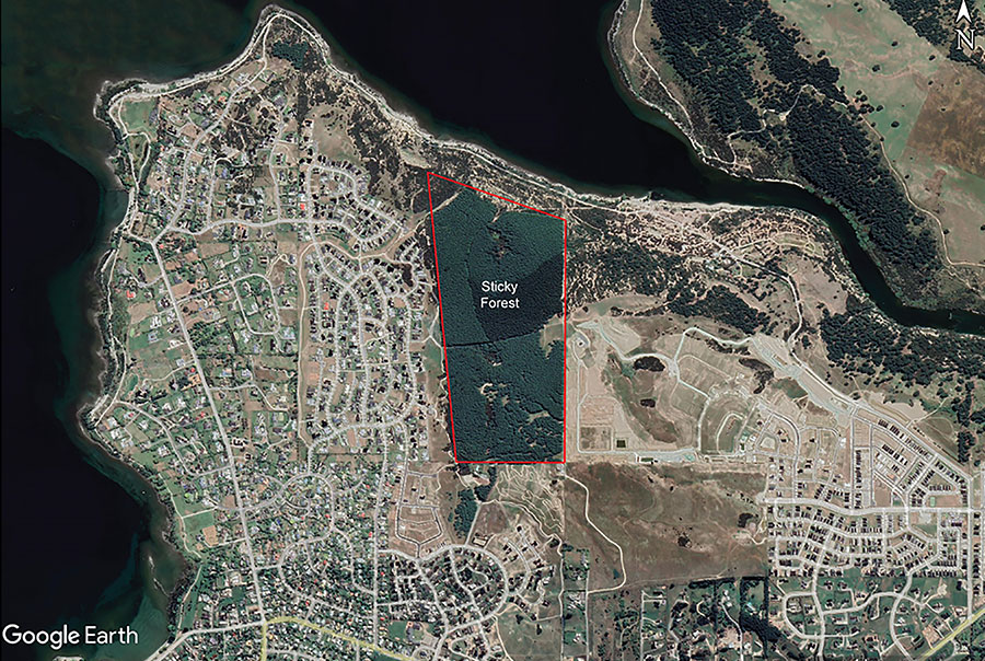
Sticky Forest is 50-hectare block on the edge of Wānaka township.
The Act
Ngāi Tahu almost immediately began petitioning the government following the failed promises of the Kemp Purchase and subsequent land deals,
and in 1886 Native Land Court judge Alexander Mackay was appointed to head a royal commission into Ngāi Tahu land claims. Mackay found the purchases failed to provide adequate reserves or compensation for the land sold. To address this, he recommended 186,112 acres be allocated to those left landless.
The government demurred. Canterbury MP William Rolleston was adamant no more land should be allocated, claiming “the allocation by Mr Mantell was most judiciously made in the interests of the Natives”. Giving more land would “tend, not to civilisation, but to the creation of an idle and degraded race,” Rolleston said, “and it is extremely desirable that no step should be taken to prevent a labouring-class from arising among the Natives”. “In the formation of that class among the Natives lies, to my mind, the future salvation of the race.”
The Waitangi Tribunal noted Rolleston’s views appeared to be “particularly influential” and Mackay’s report was “largely ignored”.
Eight years later, however, Mackay’s work was resurrected under a new government and he began a new investigation into Ngāi Tahu land claims. He found that only 10 per cent of the iwi had “sufficient” land, while 44 per cent had no land at all. This time the government agreed to do something.
In 1893, Mackay and surveyor general Percy Smith were assigned the gargantuan task of identifying all South Island Māori with insufficient land and assigning them blocks of Crown land to ensure they had a minimum of 50 acres (20 hectares) each. It took 12 years.
Mackay and Smith weren’t actually paid to do the work, either. After completing the task they noted, grudgingly, that “the whole of it has been done outside official hours, and in our own time”.
There was little Crown land left that was actually habitable and it was unwilling to buy land to give away. As Mackay and Smith noted in their final report, “much of the land is of such a nature that it is doubtful if the people can profitably occupy it”.
This seems an understatement. Some blocks were inaccessible and little more than swamps or cliff faces. A number were in Fiordland, west of the Waiau River that flows from Lake Manapouri (and an area Ngāi Tahu claims it never sold) — one of the wettest and most inhospitable parts of the country. Others were in swampy and isolated parts of Stewart Island.
The land was also arbitrarily allocated — a hapu living in Marlborough, for example, were given land near the bottom of Stewart Island.
Despite this, the Waitangi Tribunal noted, the Crown was willing to spend £2 million buying more than 150,000 hectares of former Ngāi Tahu territory during this time, breaking up large estates to ensure Europeans settlers had farmland in the south.
By 1906, 57,338 hectares across 17 blocks had been set aside for 4064 South Island Māori, which was formalised under the South Island Landless Natives Act (SILNA).
The government thought the grievances finally settled. Native Minister James Carroll said: “Generations have passed away with promises unfulfilled; but we have reached that stage now when, I think, these matters should be settled, so as to clear our consciences and rid the records of any stigma attachable to the reputation of the colony and the Government.”
The Waitangi Tribunal, however, was damning of the scheme. “The tribunal is unable to escape the conclusion that, to appease its conscience, the Crown wished to appear to be doing something when in fact it was perpetrating a cruel hoax.”
A review in 1914 found virtually none of the blocks in the lower South Island and Stewart Island were occupied by their Māori owners. The act was repealed just three years later and incorporated into the Native Land Act.
Four blocks, however, weren’t transferred to their rightful owners before the act was rescinded, and remained unallocated.
One of these was a 1658-acre (671-hectare) block, in the area known as Manuhaea, or “The Neck”, a rugged strip of land between lakes Hāwea and Wānaka.
The Settlement
“It’s a long history and it’s a sad history,” says Theo Bunker.
Bunker’s grandmother, great-grandmother and great-grandfather from Akaroa were allocated the block at the Neck — three of the 50 people allocated land there. His great-grandfather, George Teoti Robinson-Clough, had also given evidence to the Crown in 1880 during an inquiry into the inadequate reserves provided in the Akaroa purchase. It’s a kaupapa he continues.
“We’re still fighting this battle,” Bunker says. “It still hurts today that we have all of this land allocated in what was the wastelands of New Zealand. It certainly wasn’t productive land that could be farmed or anything.”
“The tribunal is unable to escape the conclusion that, to appease its conscience, the Crown wished to appear to be doing something when in fact it was perpetrating a cruel hoax.”
Bunker, 77, was unaware that he had a right to the SILNA block at the Neck until 2013, when he got a call from Ngāi Tahu genealogy expert Terry Ryan, who was working to identify descendants.
As part of Ngāi Tahu’s $170 million treaty settlement in 1998, the four unallocated SILNA blocks were to be finally transferred to the rightful descendants. The Māori Land Court was tasked with tracking down all of the successors as a first step and the Crown would hold the land until then. So far, this work has not been completed and none of the blocks have been transferred.
There was some good fortune, however. When the settlement was negotiated, the land at the Neck was also already leased, split between two high country stations. The land was mostly uninhabitable in any case — a couple of steep mountain faces, rising out of lakes Hāwea and Wānaka, while part of it had been flooded when Lake Hāwea was raised. As a substitute, the Crown offered a 50 hectare block on the edge of Wānaka township, then managed by the local council as a forestry reserve and known to locals as Sticky Forest. At the time, the land was roughly the same value as the block at the Neck, albeit about 13 times smaller.
The value of the new site soon plummeted. Through what’s been called “an administrative oversight”, Sticky Forest became landlocked. It was originally part of a larger 115 hectare block, but 65 hectares was subdivided by the Crown and Ngāi Tahu, with the proceeds going to the iwi as part of its settlement, and the balance of the land left to the SILNA descendants. However, the subdivision failed to include road access to the SILNA block at the rear. Environment Court documents claim this was because the land was subdivided under the Ngāi Tahu Claims Settlement Act, rather than under the Resource Management Act, which would have ensured access. Because the land hadn’t yet transferred to the descendants, it seems no one was advocating for their interests and the crucial road access was missed.
In the following years, neighbouring landowners gradually began developing the surrounding land through private plan changes. With Sticky Forest still basically ownerless, the block remained zoned as rural land, in an enclave outside the urban boundary.
The forest later became subject to the Emissions Trading Scheme. Because it was planted before 1990, if the site were ever cleared the owners would be liable to either buy carbon credits (amounting to about $2 million at today’s prices), or plant an equivalent amount of land in forest elsewhere.
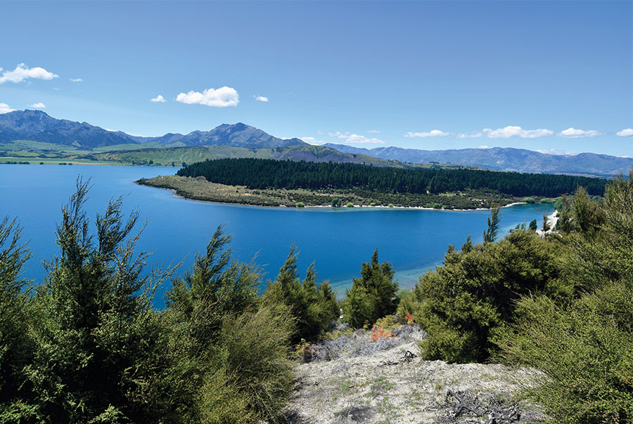
The north end of Sticky Forest has views over the Clutha River outlet and Lake Wānaka’s Dublin Bay. Photo: George Driver
Bunker says the land was essentially worthless. “We looked into it and you could farm chicken, goats or pigs, but no one’s ever going to allow you to do that in that locality because it’s surrounded by residential land,” Bunker says.
“We’ve been sitting at the top of the hill but feeling like we’re at the bottom of it. But we’ve got to climb out the other side and keep punching and maybe we’ll get something back for the owners.”
It seemed like the cruel hoax of the South Island Landless Natives Act continued.
Park Life
When Doug Hamilton moved to Wānaka in 1990, Sticky Forest soon became his playground. The land was still a council forestry reserve then, surrounded by farmland and other forestry blocks. Hamilton and a handful of others began developing some of the first mountain bike trails in the region there as the fledgling sport gained popularity, turning sheep trails into what has become a network of more than 40km of wellcared-for mountain bike trails that attract many users. (A 2020 report said an average of more than 300 cycle movements a day were recorded over one fortnight.)
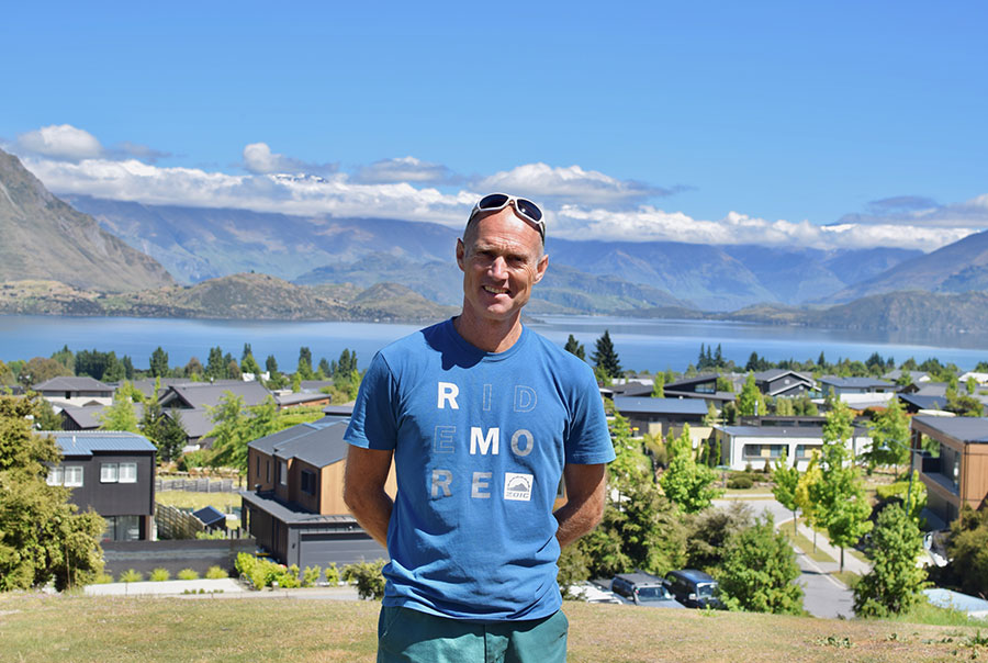
Doug Hamilton named Sticky Forest in the 1990s. He and a small group developed some of the first mountain bike trails in the region. Photos: George Driver
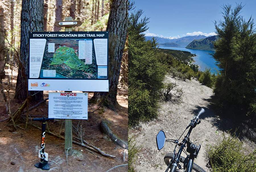
Hamilton named one of the forestry blocks Sticky Forest, due to the mess of “sticks” left after the plantation was pruned. While this block was later developed, the name has stuck to the only forestry block left. “We took that piece of land, me and a bunch of other guys and girls, and over a period of 10 years developed it from a nasty piece of forestry that no one looked after into a series of iconic mountain bike tracks that people from all around the world know about and come to ride,” Hamilton says. “We were protecting the land and always have done, because no one else has.”
Hamilton co-founded Lake Wānaka Cycling (later renamed Bike Wānaka) in 1998, to try and protect the trails from a neighbouring subdivision at Peninsula Bay. Soon, they discovered a new threat to their mountain bike park.
Hamilton says at a public meeting that year Ngāi Tahu Property chief executive Tony Sewell revealed that the council reserve at Sticky Forest would become part of Ngāi Tahu’s impending settlement. “We weren’t consulted as a community at all,” Hamilton says. “We’ve been banging away at the council ever since to do something about it. We’ve had this hanging over us ever since, because we were always told something was going to happen to it.”
For the next 17 years, however, the mountain bike community continued to grow the trail network in Sticky Forest, with public access tolerated by the Crown. Trail maps have been installed along with bespoke signs for trails, with names — including Kooza, Sick Boy and Peroxide — that are now part of the local biking lexicon. But they always knew Sticky Forest would come under new ownership at some point.
The Rezone
In 2015, three sentences foreshadowed the end of Sticky Forest’s status as a de facto park. A Christchurch property developer named Michael Beresford wrote a submission on the Queenstown Lakes District Council’s proposed district plan, calling for the block to be rezoned residential.
Two years earlier, Beresford had received a phone call from his cousin, Theo Bunker, to tell him he was an heir to the SILNA land. After doing some investigation, Beresford took the initiative of submitting on the plan, hoping some day the rightful owners of Sticky Forest might be able to develop the block. The council claimed the zoning change could enable a 765 lot subdivision in what would be one of the most in-demand sites in town.
Beresford’s submission didn’t come to the public’s attention until more than a year later, well after the public consultation period had closed, meaning no evidence could be provided in opposition to it.
Hamilton says the mountain bike community was devastated, and has been campaigning to prevent the forest from being developed ever since. In 2017, the community held a public meeting on the future of the forest, which was attended by the council’s chief executive, a number of councillors and Beresford. About 450 people turned up. Some posted on social media claiming the forest was the reason they’d moved to Wānaka.
“I think it was the biggest public meeting there had ever been in Wānaka,” Hamilton says. “We were all like ‘you can’t do this. This is our recreation land. You can’t do it. You need to go and find something else or the council needs to buy it off you’.”
Bunker describes the meeting as an ambush. “Unfortunately Mike was bushwhacked. The mountain bikers have had a political agenda to continue to use the land for free at their leisure.”
Beresford compromised, however, and later revised his submission to only rezone a third of the site as residential, leaving the remainder as rural “on the basis that it would be made available to the public for recreational purposes”. But he also said if the zoning request was rejected, “the possibility that it will be locked off from public use cannot be ruled out”.
Bike Wānaka still wanted the entire site protected. It was lobbying council to buy the site and considering fundraising for a purchase itself, but both possibilities relied on maintaining the rural zoning and lack of access to keep the price down. Spokesperson Simon Telfer said at the time “we want to see the whole of Sticky Forest become a community asset for our children and our children’s children”.
When Beresford’s submission was finally heard in 2018, commissioners recommended the residential rezoning be rejected. But they left the door open. Because there was no access to the site, they said they weren’t able to determine the impact any development would have. But they said “some form of urban development is likely to be appropriate on the site in future”. “We record that had the issue of legal access been resolved, it was likely that we would have found an urban zoning of at least part of the site to be appropriate.”
Bike Wānaka lauded the decision. Simon Telfer said “we see Sticky Forest as Wānaka’s adventure playground for many generations to come”.
Beresford appealed the decision and it has been slowly progressing through the Environment Court ever since.
The Road
Platinum Ridge and Forest Heights border Sticky Forest and feature some of the most expensive real estate in the country. Photos: George Driver
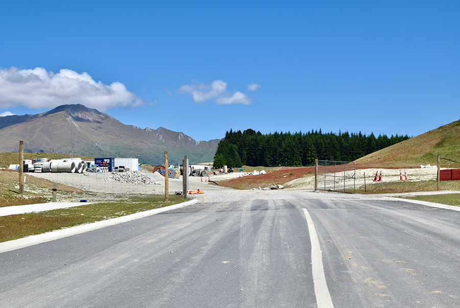
While Beresford’s case wallowed in the courts, the fate of Sticky Forest transformed via a most unusual route. In 2021, the developers behind the neighbouring Northlake subdivision applied for a fast-tracked consent to build a retirement village, bypassing the normal consent process. Somehow, the SILNA block’s access issue had come to the attention of the then environment minister and attorney general David Parker, who asked the consent hearing panel to investigate whether the development could also provide access to Sticky Forest.
It was an unexpected request. The proposed retirement village was about a kilometre from Sticky Forest, but the developer owned the block adjoining the forest. The hearings panel noted that there was no clear connection between the two sites and it “doubts whether there is a sufficient logical link between the development proposed in the application and the proposed easement”.
Nonetheless, Northlake proposed providing access via a private plan change to intensify the adjoining block and the hearing panel made this a requirement of the consent. During consultation for the plan change earlier this year, the majority of the 35 submissions opposed it, including Bike Wānaka’s. Most opposed it because developing Sticky Forest would destroy what they considered to be their public park. “Our community is at risk of losing the very thing that many of us enjoy about living here — green space,” one submission said.
Council commissioners however recommended the plan change be accepted and the council agreed last November (2023), finally resolving the access issue.
Coincidentally, Michael Beresford’s Environment Court appeal was finally heard in court the following month. Beresford died of cancer in 2021, but the case was taken up by Beresford’s cousins, Theo Bunker and Lorraine Rouse. Their proposed rezoning had again significantly shrunk to just rezoning 17 hectares of the site, with a potential 146 lots. This was partly due to an Outstanding Natural Landscape designation that council had proposed over half of the site, further restricting how the land could be used.
With the access issue resolved, the Council dropped its opposition, and supported rezoning the block to allow for up to 133 houses, though it was still opposed by the residents of the neighbouring Kirimoko subdivision. Bike Wānaka and other community groups were unable to join the proceedings because they hadn’t submitted on the district plan. A decision on the case is expected in early 2024, but with the council no longer opposed, a partial residential rezoning seems likely. “We’re starting to see the light, a little bit,” Bunker says. “We’re really elated.”
But the descendants may now be on a collision path with some of the Wanaka community. “We don’t disagree with the community having use of it,” Bunker says, “but what’s happened is that we’re now going to have to wear the backlash of any actions we take on our own land, because of that 25 years of free use.”
For Doug Hamilton, the news was devastating. “I feel so let down it’s not even funny,” he says. “Only the richest of the rich will be able to afford the land and buy a house up there. It’s not helping Wānaka at all.
“It’s a real mess. It’s basically pitching them against the Wānaka community. And something could have been done about it so long ago.”
Bike Wānaka, however, is striking a more diplomatic tone (Hamilton left the organisation a decade ago). Spokesperson Simon Telfer said the group’s in a difficult position.
“We fully respect that this was given as substitute land for the beneficiaries and they deserve economic recompense. We certainly have empathy for that, but on the other hand we have a recreational asset that people have grown up in and feel very connected with and have a strong sense of guardianship over. We’re in a tricky situation and it’s out of our hands.”
Hamilton still wants alternative compensation to be found for the descendants.
“I want to see Sticky Forest left to the community so we can carry on with what we’ve been doing for the last 30 odd years, and for the office of treaty settlements to find something else for these people. But I know they’ve all probably got dollar signs in their eyes now, because the amount of money they could potentially make out of it is enormous.”
The Vote
What happens to the forest now depends on the Environment Court decision, and the descendants’ wishes. More than 25 years since Ngāi Tahu’s settlement, the Crown has finally compiled a list of descendants, which has now reached almost 2000. In explaining the lengthy delay, a spokesperson for the Office for Māori Crown Relations, Te Arawhiti, said it’s been a difficult job. There was initially no information on the descendants and finding information on every single descendant from the original 50 beneficiaries since 1906, and contact details for all living descendants, has been time consuming. The work is said to have been under-resourced for many years, compounding the grievance.
The original 50 beneficiaries were from all over the South Island, but mostly from Banks Peninsula and Kaikoura. Now their descendants are scattered around the country, and around the world. Some remain unaware they have a share in the block. Bunker and Rouse say they still don’t have contact details for about half of the named descendants.
Now they must vote on what to do with the block. An election was held in December to elect a board of five people, who will decide on an ownership model for the forest — whether it’s held as Māori freehold land, or freehold land — and whether to hold it in a trust or company structure. They will also likely decide whether the land should be developed. Their proposal will then be voted on by the successors, probably next year.
Not all of the descendants want to see the land sold off for housing. Some standing for the board wanted to see the land retained for their long-term benefit.
Meanwhile, the future of three other SILNA blocks that were never transferred remains in limbo. These blocks were intended for more than 500 “landless natives”. Unlike Sticky Forest, they are far more isolated. None have road access and they’re all surrounded by conservation land, essentially in the middle of nowhere.
Te Arawhiti says it hopes to have a final list of successors for the 2994 hectare Toi Toi block, on the south side of Stewart Island, by next year (2025). Approximately 1800 descendants have already been identified from the original 181 owners. Then, once this work has completed, it will focus on the 647 hectare Whakapoai block. This block borders the Heaphy River on the Heaphy Great Walk, surrounded by Kahurangi National Park, and was originally given to 28 owners. And finally, Te Arawhiti will begin work tracing the descendants of the 308 original owners of the Port Adventure block, 4046 hectares on the western tip of Stewart Island.
Theo Bunker says his mahi will continue to help the other so-called landless natives finally get the blocks they were given in 1906.
“Before Mike passed away I vowed to him that when we finish ours, and we hope we’ll finish it quickly, that I would dedicate the rest of my time to helping the other SILNA blocks get off the ground. Because if it’s not started by someone, it ain’t going to start. It just becomes too hard. It’s not fair.”
George Driver is North & South’s South Island Correspondent, a role supported by NZ on Air’s Public Interest Journalism Fund.